Are satellites too close to Earth to take proper photos of the Earth?
The Internet is awash with articles about how few, if any, proper photos of the Earth have been taken from space.
The argument goes that we have launched some 10,000 satellites, launched many shuttle missions, have journeyed to the moon several times, have launched many probes into the Solar System, and have a permanently manned ISS, but no real photos.
What do they mean by 'no real photos'?
Well, if you Google "Earth from Space" you will see hundreds of images, but there is a problem with them.
There appear to be two categories of images of Earth from Space published. The first is the ubiquitous Apollo 17 shot. Apparently taken on the way to the Moon at a distance of some 100,000 miles.
 |
| Apollo 17 Full Earth Photo |
Note the distinctive cloud pattern centre image, just below the equator. This image appears in many places, sometimes 'as is' and sometimes edited.
The second category appears to be 'composite images' i.e. NOT actual photos. It is claimed that all NASA images other than the Apollo 17 'photo' are composite images and are labelled as such.
NASA explains how this image was constructed from strip images taken by instruments on this Earth Orbiting Satellite (EOS) flying at 833 km.
Apparently, NASA claims that there are no non-composite images of the Earth from Space because satellites fly too close to the Earth to take a full-frame photo, so, all they can do is to stitch together the strip images that are taken as satellites orbit the Earth.
My comments:
I have a £125 smartphone incorporating a 15mp camera. The device is not primarily a camera so let's be generous and say that I have a £100 camera (about $150USD at the time of writing). NASA probably has better equipment than me, so, if I can do something I guess that NASA can do at least as well.
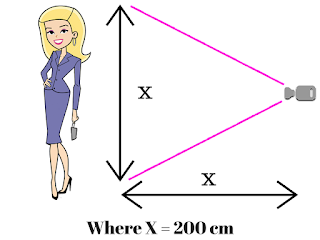
My wife is about two metres tall and I asked her to stand in our kitchen while I focussed on her with the above £100 camera. She was full-frame at about two full paces away. So, at approximately two metres distance an approximately two-metre tall woman was full-frame in a cheap camera.
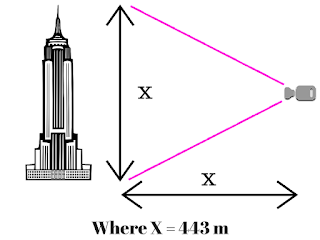
Using basic geometry, if I draw a triangle with base equal to height the units of measurement are irrelevant, the shape and the angles will remain the same regardless.
If I draw a triangle with base = height = 200 cm
or base = height = 443 m
or base = height = 12,756 km
or base = height = umpteen gazillion km
it makes no difference. Therefore, a picture taken at any distance should display a subject whose height/width is the same measurement as that distance as a full-frame image.
First I Googled "What is the diameter of the Earth" and one of the results follows:
Excerpt from About.com Geography at http://geography.about.com/library/faq/blqzdiameter.htm
What is the diameter of the earth?
The diameter of the earth at the equator is 7,926.41 miles (12,756.32 kilometers).
But, if you measure the earth through the poles the diameter is a bit shorter - 7,901 miles (12,715.43 km). Thus, the earth is a tad wider (25 miles / 41 km) than it is tall, giving it a slight bulge at the equator. This shape is known as an ellipsoid or more properly, geoid (earth-like).
Then I Googled "How high are satellites above the Earth" and one of the results follows:
Excerpt from Yahoo Answers at https://answers.yahoo.com/question/index?qid=20110825150456AARMUVC
How much miles above Earth are satellites?
Best Answer: Depends on the satellite (and the right phrasing is "how MANY miles are satellites above the Earth").
Low Earth Orbit satellites are up to about 2000 km (Americans still use miles, so you will have to do your own conversion). All human orbital spaceflights have been here, the ISS orbits here.
Medium Earth Orbits are from 2000 km to about 35800 km. This is where GPS satellites are, as well as communication satellites (like Telstar).
High Earth Orbits are above 35800 km. This is where military satellites tend to be.
CONCLUSION:
My £100 camera should have no trouble taking a full-frame photo of Earth from an altitude from 13,000km or greater.Therefore, while my camera would probably struggle to take a full-frame photo of the 13,000km Earth from a 2,000km altitude LEO satellite it should have no problem taking a satisfactory photo from some MEO satellites and all HEO satellites.
RECOMMENDATIONS:
(1) NASA purchases my £100 camera for, say, £200 (a man's gotta live, right?) and installs it on the next HEO or suitable MEO and then sends back some stunning, 15mp, full-colour, full-frame, photos of our Earth. Simples!(2) NASA supplies the ISS crew with a slightly more sophisticated camera than mine, and maybe splash out on a wide angle lens. I reckon that a budget of several hundreds of £££ might be required, but I am told that they have deep pockets.
(3) You try all the above for yourself and don't just take my word for it.


No comments:
Post a Comment